
National Geographic is wonderful dahling – esp. editions 1- 7 gazillion that are rotting in my parent’s basement. What do I know, I’m a newbie, some mom trying to pretend I’m blogging to ignore the kids! Is it possible that this could be a mistaken picture? We all make mistakes (please don’t tell my kids that I do).
So you have 2 things here:
1. a levee
2. a borrow pit
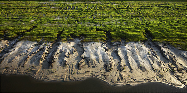
Below are some definitions that will make you snooze. But I raise the question…Is it possible the picture of the “levee” featured all over the place in the NYTimes and National Geographic are of a borrow pit and not a levee???
update: d’oh here is the picture
Sorry I used Wikipedia for a source…
Borrow pit
From Wikipedia, the free encyclopedia
Jump to: navigation, search
This article or section does not cite any references or sources.
Please help improve this article by adding citations to reliable sources. (help, get involved!)
Any material not supported by sources may be challenged and removed at any time. This article has been tagged since May 2007.A borrow pit is a term used in construction and civil engineering. It describes an area where material (usually soil, gravel or sand) has been dug for use at another location. The term is literal — meaning a pit from where material was borrowed, although without an implication of someday returning the material. Borrow pits can be found close to many major construction projects. For example, soil might be excavated to fill an embankment for a highway, clay might be excavated for use in brick-making, gravel to be used for making concrete, etc.
In some cases, the borrow pits may become filled with ground water, forming recreational areas or sustainable wildlife habitats (one such example is the Merton Borrow Pit, near Oxford in central England, excavated to provide materials for the nearby M40 motorway). In other cases, borrow pits may be used for landfill and waste disposal.
Levee
From Wikipedia, the free encyclopedia
Jump to: navigation, searchThis article is about the type of dam. See also Levee (event) or Levy for fund-raising.
It has been suggested that this article or section be merged with Dike (construction). (Discuss)
A levee, levée (from the feminine past participle of the French verb lever, “to raise”), floodbank or stopbank is a natural or artificial slope or wall, usually earthen, which parallels the course of a river. Linguists agree that the term came into English use in New Orleans circa 1672.
Contents
[hide]* 1 Artificial levees
* 2 Natural levees
o 2.1 Levees in tidal waters
* 3 Levee failures
o 3.1 Incidents of Levee Failures and Breaches
o 3.2 Environmental Health Perspective by the National Institute of Environmental Health Sciences
* 4 Levees in popular culture
* 5 See also
* 6 External links[edit] Artificial levees
Levee keeps high water on the Mississippi River from flooding Gretna, Louisiana, in March 2005.
Levee keeps high water on the Mississippi River from flooding Gretna, Louisiana, in March 2005.The main purpose of an artificial levee is to prevent flooding of the adjoining countryside; however, they also confine the flow of the river resulting in higher and faster water flow.
Levees are usually built by piling earth on a cleared, level surface. Broad at the base, they taper to a level top, where temporary embankments or sandbags can be placed. Because flood discharge intensity increases in levees on both river banks, and because silt deposits raise the level of riverbeds, planning and auxiliary measures are vital. Sections are often set back from the river to form a wider channel, and flood valley basins are divided by multiple levees to prevent a single breach from flooding a large area.
Artificial levees require substantial engineering. Their surface must be protected from erosion, so they are planted with vegetation such as Bermuda grass in order to bind the earth together. On the land side of high levees, a low terrace of earth known as a banquette is usually added as another anti-erosion measure. On the river side, erosion from strong waves or currents presents an even greater threat to the integrity of the levee. The effects of erosion are countered by planting with willows, weighted matting or concrete revetments. Separate ditches or drainage tiles are constructed to ensure that the foundation does not become waterlogged.
The first levees were constructed over 3,000 years ago in ancient Egypt, where a system of levees was built along the left bank of the River Nile for more than 600 miles (966 km), stretching from modern Aswan to the Nile Delta on the shores of the Mediterranean. The Mesopotamian civilizations and ancient China also built large levee systems. Because a levee is only as strong as its weakest point, the height and standards of construction have to be consistent along its length. Some authorities have argued that this requires a strong governing authority to guide the work, and may have been a catalyst for the development of systems of governance in early civilizations. However others point to evidence of large scale water-control earthen works such as canals and/or levees dating from before King Scorpion in Predynastic Egypt during which governance was far less centralized.
In modern times, prominent levee systems exist along the Mississippi River and Sacramento Rivers in the United States, and the Po, Rhine, Meuse River, Loire, Vistula, and Danube in Europe.
The Mississippi River levee system represent one of the largest such systems found anywhere in the world. They comprise over 3,500 miles (5,600 km) of levees extending some 1,000 miles (1,600 km) along the Mississippi, stretching from Cape Girardeau, Missouri to the Mississippi Delta. They were begun by French settlers in Louisiana in the 18th century to protect the city of New Orleans. The first Louisianian levees were about 3 feet (0.9 m) high and covered a distance of about 50 miles (80 km) along the riverside. By the mid-1980s, they had reached their present extent and averaged 24 feet (7 m) in height; some Mississippi levees are as much as 50 feet (15 m) high. The Mississippi levees also include some of the longest continuous individual levees in the world. One such levee extends southwards from Pine Bluff, Arkansas for a distance of some 380 miles (611 km).
cross-posted at NOLA.com